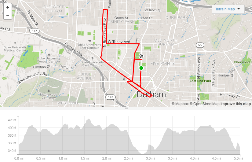


This week I’m in Northern Ireland visiting family and I’ve had to pull out my route planning toolkit, as I’m not too familiar with my surroundings.
I’m staying at my parent’s house and I need an 18-20 mile run this weekend.
PLOTAROUTE.COM
When planning a route I’m looking for safe roads with sidewalk for the duration, if possible. The first tool I use is plotaroute.com. I plan most of our group runs on this website and share the route with our crew.
As I map out unfamiliar terrain, I use google maps street view to check the route at various points to see if the road looks safe enough to run on.
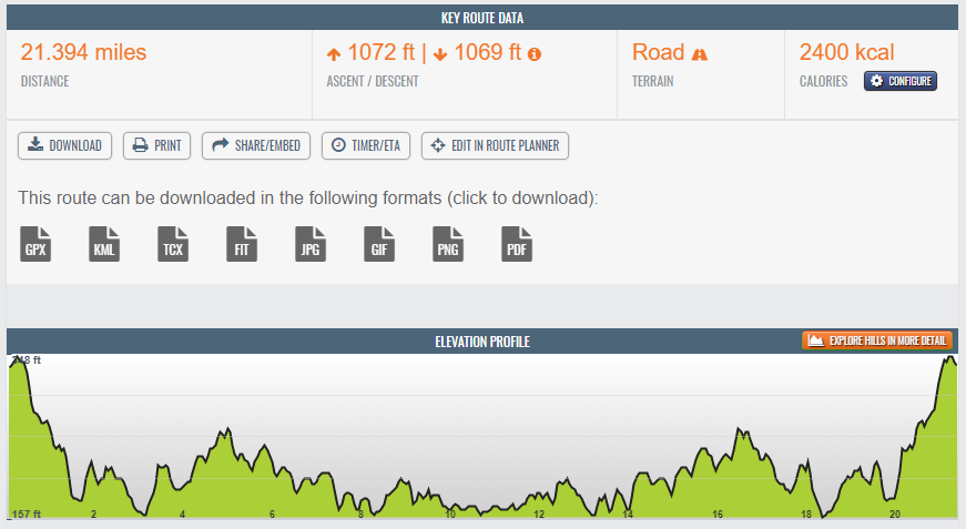
When I save the route, it calculates the elevation gain and gives options for downloading. One of the dowload options is a GPX file.
View the route here.
GPXHYPERLAPSE.COM

I take my downloaded GPX file to gpxhyperlapse.com and upload it. It uses Google Street View to capture images for the whole duration of the route. You can add modify the settings on the video to include more frames, and the delay time between each frame.
If I wasn’t planning to share the route/video with others, I’d stop here. There’s a bit more work involved in sharing the video generated by gpxhyperlapse.com.
NIMBUS SCREENSHOT

Since gpxhyperlapse does not offer a download option, I used a Chrome plugin called Nimbus Screenshot & Screen Video Recorder to record the video. There is a download button on the screen when recording completes that will allow download of the video to webm format (mp4 and other video formats are available in the paid version).
ONLINE-CONVERT.COM

I’m using the free version of Nimbus, so I need to find a different way to convert the webm to mp4. In the end I used a website called Online-Convert.com.
YOUTUBE.COM
To enable easy sharing, I uploaded the video to YouTube as unlisted. I used YouTube’s online video editor to trim the beginning and end of the video.
Here’s the final video and I think it serves as a great tool to get a feel for the route